The North Carolina State Parks and Forests are great places for hikers to discover some of the state’s most beautiful natural assets.
Educational State Forests
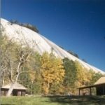
Holmes Educational State Forest
The Civilian Conservation Corps developed a nursery in the mid-1930s, primarily consisting of poplar and pine seedlings. In the late 1960s, the NC Forest Service developed the Holmes Educational State Forest, officially designated in 1977. The educational forest is open to the public for free and features five trails, an educational center, a picnic area, and a group campground. Hikes and workshops are offered regularly.
Tuttle Educational State Forest
Miss Lelia Judson Tuttle deeded the original 160 acres of Tuttle Educational State Forest land to the Tuttle Forest Foundation in 1956. Her wish was that the forest be used for education and recreation. In time, forest care was passed to the North Carolina Fores Service, and it has become an excellent example of an outdoor classroom. The property features a forestry center, picnic area, hiking trails, horseshoe pit, volleyball court, and more.
State Forests
DuPont State Recreational Forest
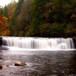 More than 80 miles of trails and roads wander through the 10,300 acres of mountain terrain in DuPont State Recreational Forest, taking hikers to six beautiful waterfalls. Hooker Falls is easily accessible year-round via the Hooker Falls Trail (0.4 miles long). Triple Falls is a 15-minute walk from the Hooker Falls parking area, and High Falls is a 15-minute walk further upstream from Triple Falls. High Falls can also be accessed from the High Falls Access Area. Stop by the visitor center for additional information. Always look at a map before heading out on a trail.
Headwaters State Forest
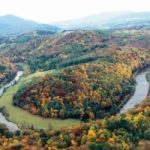
North Carolina’s newest swath of conservation land, Headwaters State Forest sprawls across 6,730 acres through mixed hardwood forest surrounding the French Broad River headwaters in Transylvania County. Headwaters ranges from about 2,000 to 3,600 feet in elevation and is crisscrossed with streams, waterfalls and hiking trails near the South Carolina border. It will help preserve and maintain water quality in the headwaters of the French Broad River, which flows 218 miles from Transylvania County into Tennessee.
State Parks
Mount Mitchell State Park
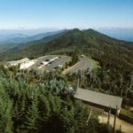
Many trails thread through Mount Mitchell State Park, which is located on the highest peak east of the Mississippi River. All trails are easy to moderate, with the exception of the Black Mountain Crest Trail, which although very scenic is strenuous and long. From the summit on a clear day visitors can enjoy spectacular views of the surrounding mountains and the Pisgah National Forest. Trail maps are available at the Park office.
From Asheville, take the Blue Ridge Parkway north to Milepost 355.4, turn left onto NC 128, which leads to the park. From Marion or Old Fort, take US 70 to NC 80, turn north and travel 16 miles to the Blue Ridge Parkway. Turn left and follow the Parkway to Milepost 355.4; turn right onto NC 128 into the park.
New River State Park
 The one-mile Hickory Trail that begins at US 221 provides a spectacular view the oldest river in North America, which is the centerpiece of New River State Park. The Farm House Loop Trail beginning at the Alleghany Access Area takes hikers through open fields, rhododendron thickets and oak/hickory woodlands for a beautiful view of the cliffs across the river.
From I-40 east of Asheville, take Exit 86 to Marion, then follow US 226 north to US 221. Continue north on US 221 through Boone to Jefferson. Turn right on NC 88 east, cross the New River and turn left on Wagoner Access Road (SR 1590).
Pilot Mountain State Park
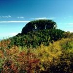 Capped by two prominent pinnacles, 1,400 foot Pilot Mountain served as a landmark for Native Americans and pioneers in days gone by. Today visitors to Pilot Mountain State Park can hike on miles of trails through rhododendron and rocky terrain. At the top, visitors can enjoy the spectacular view across the Piedmont to the mountains.
Pilot Mountain State Park is located 24 miles north of Winston-Salem and 14 miles south of Mount Airy. From US 52, take the Pilot Mountain State Park exit and travel west into the mountain section of the park.
Stone Mountain State Park
Hikers can explore the wonder of the 600-foot, 300 million-year-old granite dome, wander through densely wooded areas, and view cascading waterfalls along 16 miles of trails in Stone Mountain State Park. The strenuous Loop Trail leads hikers to the mountain’s summit and then continues to the top of Stone Mountain Falls. From there, the trail descends to the meadow at the mountain’s base and back to the trailhead. Cedar Rock Trail and Wolf Rock Trail lead to excellent views, and Widow’s Creek Trail also has backcountry camping sites.
From the Blue Ridge Parkway, take US 21 south to Roaring Gap. Turn right on Oklahoma Road and follow it for approximately 3 miles. The Park entrance is on the right. From I-77, take Exit 83 and turn west onto US 21. Veer left onto Traphill Road (SR 1002) and follow it to the John P. Frank Parkway. Turn right and follow the parkway to the Park.
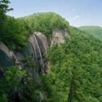
Chimney Rock State Park

The greater Chimney Rock State Park currently encompasses roughly 6,000 acres on both the north and south sides of the gorge, and expansion efforts continue to bring more of the gorge’s rich natural resources into conservation. From atop Chimney Rock, an ancient monolith soaring 1,200ft above the valley floor, guests can see more than 75 miles across Lake Lure, the Blue Ridge Mountains, and the Carolina Piedmont.
Additional Areas
Hickory Nut Gorge
The sheer cliffs of Hickory Nut Gorge rise above the rocky Broad River as it rushes toward lower elevations. Hikers along the riverbank can view the 404-foot Hickory Nut Falls that is within the boundaries of Chimney Rock State Park. Several trails within the Park take hikers to both the top and bottom of the falls.
Hickory Nut Gorge is located approximately 15 miles southeast of Asheville, North Carolina. It is accessible via US 64 from Hendersonville and Rutherfordton, and on US 9 from Black Mountain.
Mountains-to-Sea Trail
This extended trail runs as it is named, from the mountains to the seacoast and is part of the North Carolina State Parks system. The Mountain-to-Sea Trail is easily accessed from a number of points between Asheville and Mount Mitchell, generally off the Blue Ridge Parkway. Among other access points, hikers can join the trail from the French Broad River Overlook, Folk Art Center, Craggy Gardens Visitor Center, Balsam Gap and the Mount Mitchell State Park entrance road. The stretch between Balsam Gap and the Mount Mitchell Road is particularly outstanding.
On the Blue Ridge Parkway, access is at the following Milepost numbers: French Broad River Overlook, Milepost 393.8; Folk Art Center Parking Lot, Milepost 382; Craggy Gardens Visitor Center, Milepost 364.5; Balsam Gap, Milepost 359.8; and Mount Mitchell Road, Milepost 355.4.
Visit our Hiking in National Parks & Forests page as well.