Hiking in the Great Smoky Mountains National Park
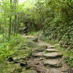
With 150 hiking trails covering more than 850 miles, the Great Smoky Mountains National Park offers hikers many options ranging from half-hour walks to week-long backpacking trips with paths rated from mild to strenuous. The Appalachian Trail runs for 70 miles along the Park’s top ridge. Some trails take hikers into remote deep woods, to waterfalls and alongside mountain streams, or past historical sites. Hiking maps and other information are available at the Oconaluftee Visitors Center in Cherokee.
Cataloochee Valley

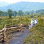
Less than an hour’s drive from downtown Asheville, just inside the eastern boundary of the Great Smoky Mountains National Park, hikers can step back in time into a quiet rural valley once inhabited by a small farming community of 1,200. Evidence of the community remains in the form of several old buildings, including a school, church, and a number of homes and barns. Elk have been reintroduced into the area and can be seen grazing in the fallow fields. Thirty-seven miles of easy to moderate trails run through the Cataloochee Valley, including the popular Boogerman’s Loop and Big Ridge Loop Trails which can be accessed from the campground parking lot.
From Asheville, take I-40 west to Exit 20 onto US 276. Follow US 276 north 0.1 mile to Cove Creek Road (SR 284) on the right. Travel 5.8 miles to Cove Creek Gap at the boundary of the Great Smoky Mountains National Park. Continue another 4.8 miles to the campground entrance. Trailheads are in the parking lot.
Hiking on the Blue Ridge Parkway
There are many trailheads along the Blue Ridge Parkway that provide hikes of varying difficulties. Two of the most popular are:
Craggy Pinnacle

Located at Craggy Gardens on the Blue Ridge Parkway, just north of Asheville, this 1.5 mile hiking trail is a favorite for visitors seeking the rich colors of summer and fall in the mountains. In June, the summits come alive with the pinks, purples, and whites of rhododendron in full bloom. In fall, the blazing reds, oranges and yellows of trees can be seen for miles. The Craggy Pinnacle Trail takes hikers on a short climb through a rhododendron thicket to a rocky top with great views of the Craggy Mountains, Black Mountains and the Swannanoa Valley.
From Asheville, take the Blue Ridge Parkway north to just past the visitor center. The parking lot is on the left at Milepost 364.1. The trailhead is at the south side of the parking lot.
Moses H. Cone Memorial Park
Twenty-five miles of carriage trails, open for hiking, horseback riding, and mountain biking, wind through the fields and forests of the 3,500-acre estate of this prosperous textile entrepreneur of the Gilded Age. Stop at historic Moses Cone Manor, a gleaming white 20-room, 13,000 square foot mansion built in 1901 in the grand Colonial Revival style. Hikers can also visit the Parkway Craft Center located there. Adjacent to the Cone Park is Julian Price Memorial Park with a placid lake surrounded by an easy walking path.
The Moses H. Cone Memorial Park is located at Milepost 294 on the Blue Ridge Parkway near Boone. The Julian Price Park is at Milepost 297.
Hiking in National Forests
The vast woodlands in the Nantahala National Forest and Pisgah National Forest provide hikers the opportunity for some amazing adventures. Many of the hikes below are accessed from trailheads on the Blue Ridge Parkway.
Graveyard Fields
One of the most popular hiking areas in the Pisgah National Forest, Graveyard Fields is a high, flat mountain valley with three stunning waterfalls and a wide variety of wildflowers and berries. Graveyard Fields Loop Trail is a moderate 3.19 mile hike which starts from the overlook on the Blue Ridge Parkway. Spur trails lead to two of the three major waterfalls on the Yellowstone Prong River.
At the junction of US 276 and the Blue Ridge Parkway in Pisgah National Forest, go south to Graveyard Fields Overlook at Parkway Milepost 418.8. From Exit 85 off U.S. 23/74 in Sylva, drive east on U.S. 23/74 for 8.9 mi. then turn left, entering the Blue Ridge Parkway. Proceed in the direction of Asheville, and go 0.8 mi. past Milepost 418, then turn left into the Graveyard Fields parking lot.
Linville Gorge and Falls
Near the town of Linville Falls, the Linville River spills into Linville Gorge, one of the most rugged and scenic gorges in the Eastern United States. Both the Falls and the Gorge are within the Linville Gorge Wilderness Area, which offers some of the premiere hiking in the region with 39 miles of trails, abundant wildlife, remnant stands of uncut forest, and the 90-foot multi-level falls. Breathtaking views of the Falls and Gorge can be had by taking trails from the Linville Falls Visitor Center. Because of the difficult terrain and sometimes dangerous conditions, hikers unfamiliar with the area are urged to contact the US Forest Service for information before setting off on the trails.
The Gorge and Falls trails can be accessed at the Linville Falls Visitor Center, located at Blue Ridge Parkway Milepost 316.4. The Wilderness Area is also accessible from US 221, NC 181, and NC 183.
Mount Pisgah and Shining Rock Wilderness Area
This popular hiking region is considered a “must see” by any serious hiker. The Mount Pisgah Trail is uphill but not too difficult and is very scenic from the top. Buck Springs Trail leaves from the same parking lot as the Mount Pisgah Trail and is a level walk that leads to the ruins of George Vanderbilt’s hunting lodge. The Shining Rock Trail follows a high altitude ridgeline and affords some of the best views in the North Carolina Mountains. Graveyard Fields (see above) is also in this vicinity.
From Asheville, take the Blue Ridge Parkway south to Milepost 407.6 to Mount Pisgah and Buck Springs Trails. The parking lot is on the left. The Shining Rock Wilderness can be accessed by turning northwest on US 276 at Milepost 412. Travel 1.25 miles to the Big East Fork Parking area. Or exit the Parkway at Milepost 420.2 on FR 816. Go 1 mile to the parking area from which Ivestor Gap Trail leads into the wilderness.
Roan Mountain
Several trails lead through the rich diversity of plant life on Roan Mountain, from spruce-fir forests to large grassy balds, but the area is most noted for its spectacular display of rhododendron blooms in June. An easy, paved trail starts at the information cabin and winds through rhododendrons to an overlook. From there, it is an easy walk along a short 0.3-mile loop or on a longer, figure-eight loop. The Cloudland Trail is a moderate, 1.2-mile hike from the end of the Cloudland parking area to Roan High Bluff Overlook. A ten-mile stretch of the Appalachian Trail also passes through the park with a trailhead at Carver’s Gap.
From the junction of NC 226 and NC 261 in Bakersville, take NC 261 north almost 13 miles to Carver’s Gap on the North Carolina-Tennessee line. Follow SR 1348, a two-mile spur road from Carver’s Gap to the Roan summit parking and trails. This spur road is open from May until late October.
Wayah Bald

“Wa ya” means wolf in the Cherokee language, and this bald is named for the red wolves that once lived on its slopes. A fire tower was built on Wayah Bald in the 1930s by the Civilian Conservation Corps, and it remains a popular hiking destination today. Two long-distance trails, the Appalachian Trail and the Bartram Trail, cross at the tower, which affords great views of the southern Appalachian mountains in three states.
From Franklin, travel west on US 64 to Old US 64 (Old Murphy Road). Turn right and go 0.2 miles to SR 1310 (Wayah Road). Turn left and continue for 9 miles to Wayah Gap, then turn right on FR 69. Follow the gravel road for 4.5 miles to the parking area.
Whiteside Mountain
Hikers can enjoy the moderate two-mile loop trail that leads around Whiteside Mountain to its summit at 4,930 feet. The high ridgetop above the steep south-facing cliffs offers spectacular views of other mountains in the area. An old-growth forest of northern red oaks, with trunks twisted by strong winds and ice storms, is found at the summit.
Whiteside Mountain is located south of US 64 between Highlands and Cashiers. From Highlands take US 64E about 5 miles. Turn right on SR 1680 and follow the signs.
Hiking at the Carl Sandburg Home National Historic Site
Five miles of hiking trails wind through the rolling pastures and woodlands of Connemara, the North Carolina farm of renowned poet and author Carl Sandburg. Visitors may stroll through the flower and vegetable gardens and apple orchard to the lakes and ponds on the property, which is designated a National Historic Site. The trails are easy to moderate except for a short steep segment of the Glassy Mountain Trail. Trail maps are available at the main house.
The Carl Sandburg Home is located three miles south of Hendersonville, off NC 225. From I-26 take Exit 53. Turn right onto Upward Road if traveling east; turn left onto Upward Road if traveling west. At intersection with US 25, continue straight. (Upward Road is now North Highland Lake Road.) At the light at NC 225 turn left (south). At next light take a right onto Little River Road. Visitor parking is on the left.
Hiking on the Appalachian National Scenic Trail
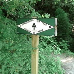
The 2,175 miles of the Appalachian Trail appeals to the hardy hiker, but for those who want a taste of the Appalachian Trail (AT) but not a long distance experience, Max Patch south of Hot Springs is on the AT and an easy quarter-mile hike from a parking lot. The 4,600-foot mountain was cleared and used as pastureland in the 19th century. Today the open crest is a favorite picnic destination with 360-degree views. From the summit of Max Patch, hikers can explore the Appalachian Trail in either direction. Twenty miles to the north, the AT runs down the middle of the main street in Hot Springs, the only town on the Trail in North Carolina.
From downtown Hot Springs, follow NC 209 for 7.3 miles to Meadow Fork Road (SR 1175). Go 5.3 miles to SR 1181. Follow 1181 for 2 miles (turns into gravel). At the top of the mountain, turn right onto SR 1182, then travel three miles to the Max Patch parking lot.
Hiking on the Overmountain Victory National Historic Trail
 The Overmountain Victory National Historic Trail runs from Virginia, through North Carolina, ending at Kings Mountain National Military Park in South Carolina. It is the route traveled in 1780 by the rag-tag band of Patriots known as the “Overmountain Men,” an untrained but determined group of soldiers who defeated the British at the Battle of Kings Mountain, a victory Thomas Jefferson believed “turned the tide of the Revolutionary War.”
Each year the Overmountain Victory Trail Association conducts a two week long commemorative march along the route to trace the 1780 campaign. Highlights include special events and ceremonies, as well as opportunities to walk portions of the historic trace. A map of the OVT is available from the National Park Service.
This page is part of our Hiking section. Also visit our Hiking in State Parks & Forests page.